 I decided to read this book since I've been doing maps using R. Hence it is better to learn the literature and science behind mapping and how to do a proper analysis on it. In addition, I would like to see what Python can offer in this discipline.
The book has 10 chapters contained in a 364 pages. The first three chapters was a long reading, not much on coding, but rather on discussions of introduction to Geospatial Analysis.
Impression:
I like the idea that the author spent three chapters talking about the overall story (I would say) of Geospatial Analysis. Just a preview, the first chapter is of course the introduction; second is the data types, which surprisingly has a variety of formats; and third is all about the libraries and packages used in the said study. I am familiar with ArcGIS and QGIS, but this book lets you aware with other tools as well.The simple illustration that complements the discussion is very helpful in telling the overall story of the subject. And the step-by-step tutorials are easy to follow (just what the book's description suggest), this is one thing that Packt books never frustrates me.
The real action begins in chapter 4, where you start to know the first few tools below,
- Python Version 2.x (minimum 2.5)
- GDAL/OGR Version 1.7.1 or later
- GEOS Version 3.2.2 or later
- PyShp 1.1.6 or later
- Shapely Version 1.2 or later
- Proj Version 4.7 or later
- PyProj Version 1.8.6 or later
- NumPy
- PNGCanvas
- Python Imaging Library (IPL)
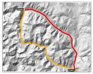
The fun commenced in chapter 5, then all the way to chapter 10. Because here, you get to play with maps. Sample from the book,
 |
| Possible Routes |
 |
| Coded in Python to search for lowest-cost route possible |
When it comes to topics discussed in this book, I can't say more. Everything is just cool, the techniques shared by the author are undeniably worth to study.
Suggestion:
I know some readers may disagree on me, but I still find it easy to refer if the installation of the modules were placed in one chapter (like appendix). By the way, the procedures for unloading and installing these tools are covered in the relevant chapters of the book as needed.
Conclusion:
In conclusion, I would say the book is a useful reference for Geospatial Analysis, especially if you prefer to do it in an open-source program with full controls on every manipulation you want. I encourage you to grab a copy, the author has a remarkable experience in this field.
Disclosure:
I was provided an electronic copy of this book for review by the publisher.
Packt $5 Bonanza:
Packt is now offering $5 Bonanza until January 3! Visit here: http://bit.ly/1jdCr2W

Comments
Post a Comment